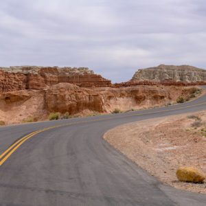
Kodachrome Basin State Park

Image via Wikipedia
Kodachrome Basin is a state park of Utah, United States. It is situated 5,800 feet (1,767. 8 m) above sea level, 12 miles (19 km) south of Utah Route 12, and 20 miles (32 km) southeast of Bryce Canyon National Park. It is accessible from the north from Cannonville by a paved road and from the south by Road 400, a dirt road from the Page, Arizona area to Cannonville, passable for most vehicles in dry conditions. A longer but paved route to Tropic from the south is also available via US-89 and SR-12.
Nearby Locations:
| Willis Creek Slot Canyon Trailhead (6.1 miles) Bryce Point (10.7 miles) Bryce Canyon National Park (12.8 miles) Yellow Rock (18.4 miles) Grand Staircase-Escalante National Monument (18.7 miles) | Toadstool Hoodoos (29.1 miles) Devils Garden (Grand Staircase–Escalante National Monument) (32.1 miles) Buckskin Gulch (36.3 miles) Duck Creek Village (36.7 miles) Coyote Buttes (38 miles) |
Maps & Directions:
Get Driving Directions:
Kodachrome Basin State Park, Cannonville
Cannonville, Utah 84718
This time, it's OK to leave a trace (Review)
There are no reviews yet. Be the first one to write one.
Submit a review of Kodachrome Basin State Park
This article uses material from the Wikipedia article “Kodachrome Basin State Park“, which is released under the Creative Commons Attribution-Share-Alike License 3.0.