Wandering the Pacific Northwest for a Weekend Roadtrip
Locations Visited:
Living in Las Vegas for three years, I spent a lot of time driving around the southwest, as Utah, Arizona and California were all within a few hours from home. However, despite my extended tenure in the Pacific Time Zone, I never actually made a trip up to the Pacific Northwest in my time out west.
On a recent long weekend, I wandered the PNW with a fantastic drive around the region highlighted by stops at Mt. Rainier, the Columbia River Gorge, Mt. Hood, before a fantastic day on the breathtaking Oregon Coast. What follows is a semi-chronological recounting of my Pacific Northwest trip accented by a few of my favorite photos from the trek.
Over the years, I’ve been to Oregon and Washington a few times, including a cross-country Minneapolis to Portland trip that covered much of the Trans-Canadian highway. That trip included a hike at the criminally-underrated North Cascades National Park, and that day in particular left me wanting to return for another photography trip. For reasons unknown, another Pacific Northwest visit never came to pass until I’d already moved back to the East Coast.
Taking a long weekend to see the Pacific Northwest certainly won’t allow you to cover the entire area in depth, but it does afford the opportunity to cherry-pick some of the best regions and take in some spectacular sights. I sought out some of the iconic waterfalls and viewpoints, hiked incredible trails and absorbed incredible sunsets.
On this particular voyage, I arrived mid-afternoon on a Friday in Seattle, with designs on catching sunset at either Olympic National Park or Mount Rainier National Park. Up until landing at Sea-Tac, I hadn’t decided upon my direction for really any of the trip. These days, I like to have a framework plan — essentially a list of locations grouped by proximity, rather than booking hotels ahead and locking myself into specific destinations. I know when and where I’m arriving, and when I’m leaving. Beyond that, I’ll pick a few spots of interest each day and weave together a loose itinerary that ties a handful of locations together without over-extending myself into too much driving between destinations.
Generally, this approach is effective for me, and rarely have I found myself scrambling for accommodations at the end of a long day of driving. You’ve got to be flexible, resourceful, and ready to call an audible when the situation demands it. I find it’s the most enjoyable way to travel solo.
Friday: Purple Mountain Majesty at Mt. Rainier
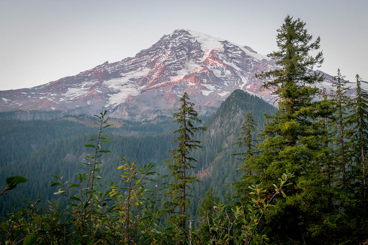
Mt. Rainier at sunset, Mt. Rainier National Park in Ashford, Washington on October 2, 2020. Photo by Peter Stringer for Amazing America.
Deciding upon Mount Rainier at the Enterprise Rent-a-Car counter, everything looked great until I got in my Nissan Altima, synced Bluetooth and checked the Google Maps time estimate. Thanks to a re-emerging Seattle rush hour, it was going be tight to get to Mount Rainier National Park with much time to spare for a sunset photo op. That estimate also assumed I’d make no stops between the airport and the park, or along the road in the park itself. Given that my trips generally focus on landscape photography, I find myself pulling over quite a bit when a scene captures my imagination. That’s not unique, but it does tend to encroach upon efficiency.
I’ll opt for a great photo over an on-time arrival at the next destination. In the case of Mount Rainier National Park, on the way up the mountain, there were a few spots that I passed up due to time constraints. Particularly, Tahoma Creek provided a picturesque view of Rainier, but alas, there was no obvious spot to park the car and take the shot.
I did manage to find a few other pull-offs worthy of the camera, but time was not on my side. I knew there was more laborious mountain driving to be done. As you climb on Paradise Valley Road, you’re greeted with many scenic switchbacks, narrow lanes and a bit of white-knuckle driving. Like many mountain roads, this one requires extra attention despite the incredible distractions around each corner and hairpin turn.
Christine Falls bridge was saved in my Google Maps, but the sun already was setting, so while I stopped quickly, I found no safe spot to set up for a long exposure to properly capture the waterfall, at least not without a hike. A trek down under the bridge would have done the trick, but I didn’t want to miss out on the sunset view from Ricksecker Point. I’d originally envisioned a picture at Reflection Lake, but that location was at least another 20 minutes up the road, and as golden hour fades into sunset and dusk, light changes by the minute. I didn’t want to risk running out of light before I could get anything representative of what I’d seen on this night already.
The view before you even get to Ricksecker is pretty iconic, and just as I arrived, the snow-capped peak of Rainier was glowing auburn. That hue quickly shifted magenta and into lavender. Shadows danced on the mountaintop as I set up my tripod and started capturing the scene. While the blue sky already had dissipated into the night sky, yielding a gray backdrop, the summit still cut a stark contrast across the sky.
Also of note: the peak of Mt. Rainier is enormous up close!
Despite the mountaintop being the main event, as I pressed on to Ricksecker Point proper, the western sky was glowing amber. The Nisqually Valley below the ledge stretched on for miles, following the jagged cut of the river.
It was undeniable: the scene to the west was even more impressive than the famous peak. Layers of mountains in the distance all absorbed their own soft blanket of blue, providing sharp contrast against the red-orange sky, scarred only by streaking clouds refracting the last minutes of daylight.

Ricksecker Point in Mt. Rainier National Park in Ashford, Washington on October 2, 2020. Photo by Peter Stringer for Amazing America.
While I could have pressed on further along several more miles of winding road, it already had been a long day of travel. Daylight had been all but stolen, so I retraced my drive down Rainier west toward the Pacific. With the next day’s destination not yet set, I decided to head back toward Interstate 5, find lodging for the night, and map out my Saturday. Kelso did the trick, putting me in striking distance for either Olympic National Park or a foray south into Oregon.
Saturday: Putting the “gorgeous” into river gorge
If you’re into hiking and waterfalls, the Columbia River Gorge is a vista-rich environment. At the time of my trip, Oregon was still recovering from a rash of well-documented wildfires. While air quality had mostly rebounded, several trails along the legendary gorge were closed for safety. Falling timber from dead and scorched trees still presented real threats, reducing access to some of the area’s most popular natural attractions.
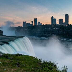
Perhaps the most famous falls of the region, Multnomah Falls, had just re-opened, despite signs on Interstate 84 suggesting otherwise. Two million people visit the falls annually, looking to admire the 620-foot plunge of Multnomah Creek. While it’s not nearly as famous as Niagara Falls, and doesn’t have the same footprint as Niagara (or even Idaho’s Shoshone Falls), in some ways Multnomah might be the nation’s most beautiful based on its surroundings.
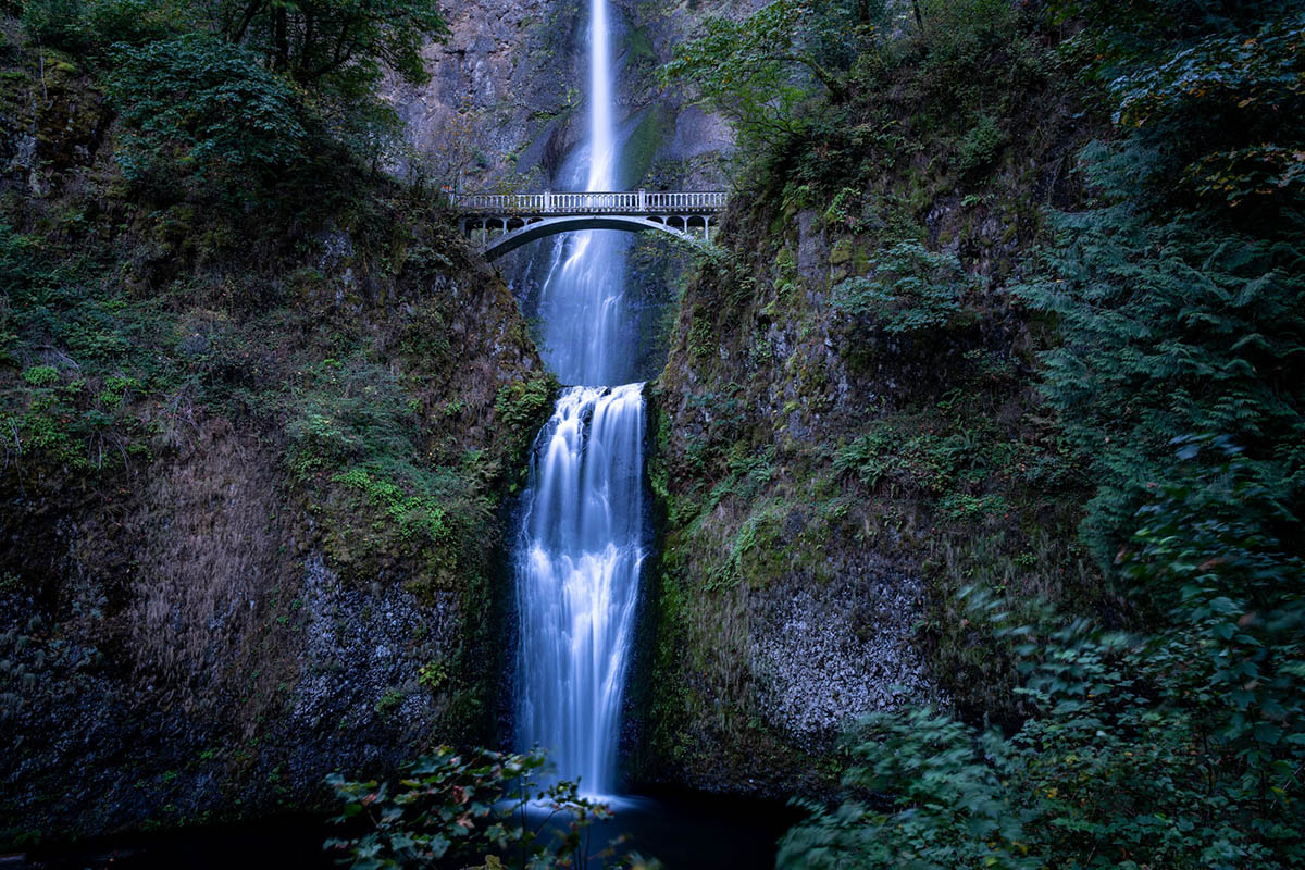
Multnomah Falls, Columbia River Gorge National Scenic Area in Oregon on October 3, 2020. Photo by Peter Stringer for Amazing America.
The falls sit in the shadows during the morning, and the scene feels like it belongs in a jungle on another continent. The long-exposure photos I took over several minutes with a 9-stop filter rendered the frame full of drab forest green and gray hues, giving the scene an extra dose of mystery and a rainforest vibe.
Multnomah Falls features a small viewing platform at ground level where you’ll get a great vantage point. Selfies are popular here for obvious reasons, and the height of the falls delivers an impressive backdrop. If you’re willing to do a little hiking you can observe the falls up close, courtesy of the elevated Benson Bridge. When I was there, the trail was closed, leaving the foot bridge devoid of tourists and providing a much more natural photo from the main viewing area.
Just East down the road is Horsetail Falls, a much smaller and significantly less famous waterfall, but it’s certainly worth a stop when you’re in the neighborhood. Unsurprisingly, the best way to describe the falls appearance is, well, you guessed it, a horse tail. Especially with a long exposure shot, the metaphor comes to life, assuming said imaginary steed is blessed with glorious flowing white locks.
Close to the borderline
The Columbia River, like many rivers across America, provides a natural border for neighboring states. In the case of Washington and Oregon, the divide is vast, yet not overwhelming. There are several crossing opportunities, however, the Bridge of the Gods is the pre-eminent option. If you don’t love heights, the brief drive 141 feet above the Columbia River may be slightly harrowing. For extra anxiety, even in dry conditions, you’ll feel your tires sliding a bit on the steel truss cantilever bridge.
The bridge stands out due to its size and ornate structure. It gained notoriety a year after its 1926 construction when Charles Lindbergh flew the Spirit of St. Louis both over and underneath it in a barnstorming gambit. Nearly a century later, the bridge was featured in the 2014 film, Wild, which chronicled Cheryl Strayed’s journey along the Pacific Crest Trail, spawning much greater awareness among tourists and locals alike.
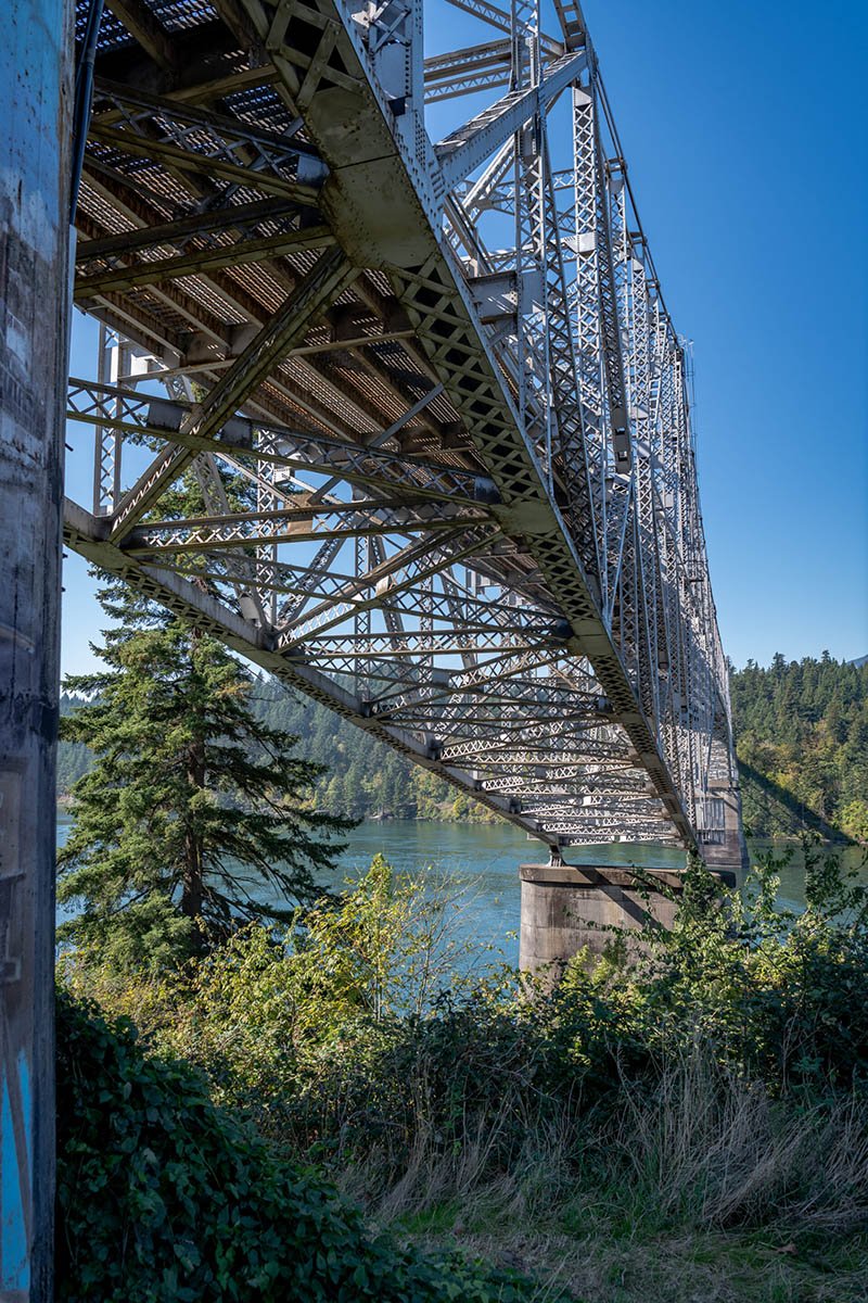
Bridge of the Gods, Cascade Locks, Oregon on October 3, 2020. Photo by Peter Stringer for Amazing America.
Those who thru hike the PCT must cross the bridge in the middle of traffic, as there is not yet a dedicated pedestrian (or equestrian!) lane. While I didn’t encounter any backpackers or horses on crossing, it’s still quite a common sight in 2020.
Across the river in Washington along Route 14 (the Lewis and Clark highway), the early afternoon views were grand, if not a bit flat thanks to the overbearing sunlight. Light-diffusing clouds were nowhere to be found. Direct sunlight produces lens flaring, harsh shadows and washed out colors.
Mid-day is always considered less-than-optimal by photographers, but with limited time in the PNW, you roll with it and shoot for the best.

Columbia River Gorge, Washington, on October 3, 2020. Photo by Peter Stringer for Amazing America.
Tamanawas Falls hike exceeds length and expectations
With four or five hours of solid daylight remaining, I set out for a hike on Mt. Hood. The only question was, what trail should I undertake for the afternoon? With Tamanawas Falls already on my radar because it’s ranked as one of the region’s best waterfalls by Amazing America, the decision was easy.
The hike wasn’t quite as easy, as I’d soon discover.
Crossing back to Oregon over the Hood River Bridge, it’s about a 45-minute ride to the Tamanawas Falls Trailhead. Upon arrival, I was greeted by a full parking lot, and a few hikers returning from their morning trek. Asking them if the proverbial juice was worth the squeeze, they re-assured me I’d made a great choice.
While the overall elevation gain is modest at 560 feet, there’s definitely sections along the trail that require a bit of effort at the onset of the hike, and certainly in the home stretch as you approach the falls.
The trail is said to be 3.4 miles, but the estimate doesn’t seem accurate when you undertake the trail. In particular, if the route really is 1.7 miles, it takes a lot longer to get to the 1.5-miles-to-go marker than a .2 mile hike that simple math would suggest.
Regardless of the true distance, early on, you’ll encounter a bridge across Cold Spring Creek, which provides a classic nature scene. Just as I arrived and climbed down to the water’s edge and started setting up my tripod to capture the crackling creek, the sun started peering through the trees.
I was in the right place at the right time for this shot. The scene was near perfect.
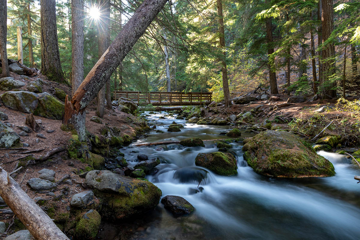
Cold Spring Creek in Mt. Hood, Oregon on October 3, 2020. Photo by Peter Stringer for Amazing America.
Autumn had just started in Oregon, and leaves were beginning their transformation. I was probably a week or two ahead of peak foliage for the region, but yellow and orange leaves were starting to emerge in some of the more shaded areas of the trail.
Aside from the exposed roots of ubiquitous trees, lying in wait to trip a distracted backpacker, the middle portion of the hike was relatively flat. That is, until you arrive at the boulder field. You’ll have to negotiate hundreds of large rocks to reach the home stretch of the journey.
You’ll also need to be at least reasonably spry to get across this portion of the trail, and it’s not well marked. Just beyond the rocks lays a brief patch of forest leading to the andesite cliffs that play host to the falls.
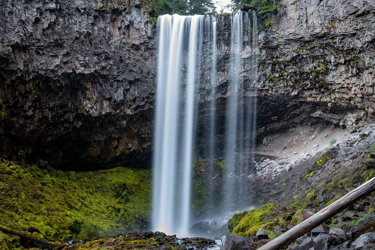
Tamanawas Falls near Mt. Hood, Oregon on October 3, 2020. Photo by Peter Stringer for Amazing America.
As I arrived at the base of the falls where the water curtain meets the creek, I had an awful realization. Somehow, I’d cracked the UV filter on my camera’s lens. The lens sat unscathed, but I couldn’t pry the shattered filter off my camera with only my bare hands. While that crack was off-center enough to not encroach upon my photos if I zoomed considerably, it made wide-angle shots impossible, severely limiting composition options.
I had done most of the hike with my camera in hand, snapping along the trail often. I must have managed to crack the lens somewhere in the boulder field. While I was still able to get some decent shots, it definitely killed my enthusiasm for reaching the falls. I also realized that I was running out of daylight, and still had to hike back out. I’d already learned that the 1.7 mile return was going to be lengthier than advertised.

Tamanawas Falls Trail in Mt. Hood, Oregon on October 3, 2020. Photo by Peter Stringer for Amazing America.
Given the lens snafu, I didn’t end up spending as much time at the falls as I’d initially planned. I didn’t get all of the shots I’d imagined before the hike, but it was still a memorable excursion. The hike back, as they always do, seemed much shorter and quicker than the walk in, but certainly longer than 1.7 miles – I don’t care what the signs say!
Tired, sore and starving, I retreated to the Columbia River Gorge, and found dinner in Hood River. I’d earned a hamburger, fries and a Jameson-Ginger, dammit, and I dialed up exactly that at Whiskey Tango on Oak Street. Effectively the main drag in Hood River, Oak St., features several different restaurant options, but, as far as I’m concerned, I found the right spot. The burger was spot on, served quick, and I would guess that Whiskey Tango is otherwise a hot spot in non-pandemic times.
Sunday: Where the mountains meet the sea
Crescent Beach view from Ecola State Park in Clatsop County, Oregon on October 4, 2020. Photo by Peter Stringer for Amazing America.
While I planned the trip as a long weekend, since I’d flown into Seattle, Friday and Monday were effectively travel days, which meant Sunday would be my last full day to explore.
The Oregon Coast is known for its dramatic landscapes, rugged shores and spectacular sunsets. Left to my own devices, that’s about all I would have likely seen, and I would have gone home happy. However, when I was sure I’d have a full day to explore the coast, I figured it may be helpful to have a local to point me in the right direction.
So I pitched Amazing America’s Kristy Podruchny on being my Oregon Coast tour guide for the day, and she obliged. Kristy spends her days in Oregon chasing waterfalls and incredible hikes around the region, and has a rolodex of ideas for a day of exploration.
Leaving the Portland area, I made the drive out Route 26, a drive under what appears to be a canopy of trees for much of the trip. When you finally reach Route 101, the views change to coastline. Heading south, I made a quick stop to capture shots of Haystack Rock, a 235-foot basalt sea stack formed by lava flows 15 million years ago.
I met Kristy around noon at Short Sand Beach, a popular spot that was once only known among surfers, inside of Oswald West State Park. The beach isn’t visible from the parking lot, but instead, you hike a forested trail to the water. It’s a little extra work for the surfers dragging their boards through the woods, but it’s a spectacular way get a flavor for Oregon’s unique coastal landscape.
As the name would imply, there isn’t a ton of sand even at low tide here, and conditions can change quickly. Multiple times, Kristy reminded me while I took photos, “never turn your back on the ocean!” Sneaker waves, as their name would also imply, are especially large waves that literally sneak up on you and won’t hesitate to carry you out to sea. Generally, October to April is considered sneaker wave season.

Kristy Podruchny keeps an eye on the Pacific Ocean at Short Sand Beach in Oregon on October 4, 2020. Photo by Peter Stringer for Amazing America.
While I shot photos on the rocks, Kristy kept an eye to the Pacific. Thankfully, we managed to stay dry and stay ashore.
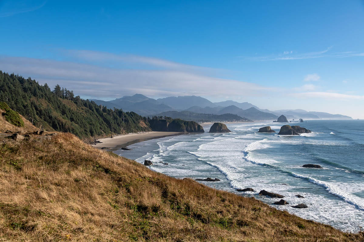
After quite a bit of hiking around the beach and woods, it was time for lunch, which meant a drive up north and stop in at the touristy Cannon Beach. We took tasty wraps to-go from Seasons Café, then ventured north to Ecola State Park, which provides even more incredible views of Oregon’s epic North Coast. But even more impressive may be the spooky old growth forest that feels like something out of Harry Potter.
The park is situated up a narrow, winding dirt road with blind curves, so stay at attention. Oncoming traffic is light, but sudden. When you reach the parking lot, you’ll find a few picnic tables and a fantastic ocean overlook, with stunning Crescent Beach off to your left.
Had you been here in 1990, you might have found Arnold Schwarzenegger filming Kindergarten Cop, as noted by signs marking the Oregon Film Trail. Fans of the cult classic 1980s film, The Goonies, will also recognize Ecola State Park, as it featured heavily in the picture.
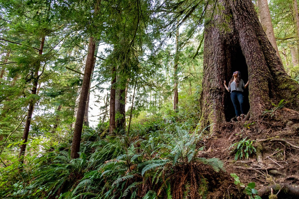
Old Growth Forest at Ecola State Park in Oregon on October 4, 2020. Photo by Peter Stringer for Amazing America.
As you approach the forest on the Clatsop Loop Trail, you enter a tunnel of trees that suddenly grows dark thanks to a thick foliage cover that dampens sound and diffuses sunlight. The climb is largely uphill, but you’ll get to see some of the largest and oldest trees on the planet. Surrounded by Sitka spruce trees, ferns, moss, mushrooms and nurse logs, you’ll get lost in worth that feels far from the ocean despite its close proximity.
These ancient trees are impressive in their height and circumference alike, especially if you’re coming from the east coast where timber doesn’t quite grow like this. Lewis and Clark famously explored this forest, and you’ll find notes from their diaries on placards along the trail.
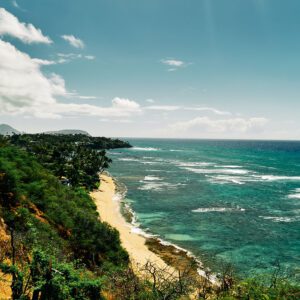
Among the Pacific Northwest’s many characteristics, perhaps the most striking is the way in which large mountains run up along the coastline. This feature makes for dramatic landscapes along the ocean’s edge up and down the Oregon coast. One minute you can be hiking in a massive old growth forest, and the next, you’re watching a sunset with your toes in the Pacific.
Seated below the forest is Indian Beach, which is a fantastic place to take in such a sunset, with the face of the cliff to the north, and jagged rock formations to the south. The scenic beach was featured in the finale of the Keanu Reaves 1991 FBI flick Point Break, standing in for Bells Beach in Australia.

Sunset at Indian Beach, Ecola State Park, Clatsop County, Oregon on October 4, 2020. Photo by Peter Stringer for Amazing America.
On this particular Sunday night, the beach was mostly deserted by sunset, aside from one last surfer who came ashore with his board over his head. Perhaps a stunt double for Keanu?
The sky put on a show after sundown, with pinks and purples cutting across the horizon. Perfect timing for some final photos of the Oregon coast.
With a flight the next afternoon in Seattle and nearly four hours of driving to go, I shot North up the coast back into Washington, stopping at Long Beach for the night.
Monday: Searching for skyline in Seattle
Having never been a morning person, and tired from a few days of hiking, I slept in on Monday morning in Long Beach, which unfortunately meant I had to pass on exploring nearby Oysterville, WA. Instead, it was time to head up the coast and inland toward Sea-Tac. With an extra hour to spare given my timeline to make my flight, I decided to head into Seattle in search of a classic skyline photo.
There are several location options for a Seattle skyline photo, including Gas Works Park, which was recommended by a few locals, but I settled upon Kerry Park. The park is a small overlook in an otherwise quiet neighborhood just northwest of downtown.
Unsurprisingly, the park was crowded at mid-day with iPhone selfie-seekers, but a park bench and fence provided ample opportunity to set up an unobstructed tripod. A thick layer of clouds behind a hazy skyline framed the photo against trees in the bottom of the frame.
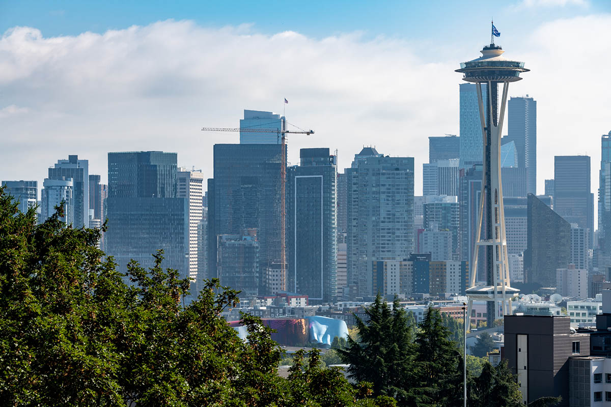
The Seattle skyline from Kerry Park in Seattle, Washington on October 5, 2020. Photo by Peter Stringer for Amazing America.
This shot is probably more impressive at sunset, but I had a plane to catch. For a 10-minute mid-day effort, I was pretty happy with the results.
From there, it was back through the city and on to the airport. I experienced quite a bit over a long weekend, but there’s so much more awaiting on my return to the PNW.
Videos:
This time, it's OK to leave a trace (Review)
There are no reviews yet. Be the first one to write one.